What is Latitude and longitude of world | The universe scale
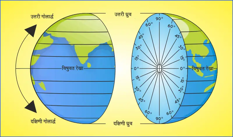
What is Latitude and longitude – The Network Of Imaginary Lines By Which The Positions Of Different Places On The Earth Can Be Determined Are Called Lines Of Latitude And Longitude. The Horizontal And Vertical Lines Shown On The Globe Closest To The Earth Are Latitude And Longitude Lines.
Latitude ( Latitude )
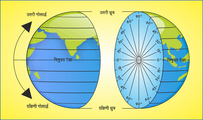
The Angular Distance Of A Place From The Equatorial Plane Towards North And South Direction Is Called Latitude Of That Place. The North Side Of The Equatorial Plane Is Called The Northern Latitude And The South And South Latitude Are Called. The Spherical Earth Has A Total Of 360 Latitudes. 0° Latitude Is Represented By The Equator, Which Divides The Earth Into Exactly Two Equal Parts. This World Is The Greatest World On Earth. From The Equator 90° Latitude Is Towards North And 90° Latitude Is Towards South. 90° North Latitude Is Called The North Pole And 90° South Latitude Is Called The South Pole.
Latitude ( Lines Of Latitude )
The Imaginary Lines That Pass Through Those Places Which Have The Same Angular Distance In The Same Direction From The Equator Are Called Latitude Lines. All Latitude Lines Are Parallel To Each Other. From The Equator To The North And South, The Extension Of These Lines Decreases. At The Pole, The Extension Of These Lines Remains Only One Point. Apart From The Equator, Cancer And Capricorn Are The Other Major Latitude Lines.
Tropic Of Cancer- On June 21, The North Pole Is Inclined Towards The Sun At An Angle Of 23-. That Is, On This Day The Sun’s Rays Fall Vertically At 23-North Latitude 2, This Latitude Is Called The Tropic Of Cancer.
Tropic Of Capricorn – On December 22, The South Pole Is Inclined Towards The Sun At An Angle Of 23- Ie, That Is, On This Day The Sun’s Rays Fall Vertically At 23- South Latitude, This Latitude Is Called The Tropic Of Capricorn.
Longitude ( Longitude )
The Angular Distance Of A Place From The Prime Meridian I.E. 0° Longitude Towards East Or West Direction Is Called Longitude Of That Place.
Longitude Lines ( Lines Of Longitude )
Those Imaginary Lines Which Are Drawn In Such A Way That Passing Through The North And South Poles Intersect The Equator At Right Angles, They Are Called Longitude Lines, All These Lines Are Equal Elongated Circles. Because All Lines Of Longitude Pass Through The North And South Poles, They Are Not Parallel To Each Other Like Lines Of Latitude. The Distance Between Them Is Maximum At The Equator And The Distance Between Them Decreases As We Move Towards The Pole. On Poles, These Lines Meet At A Single Point. Longitude Lines Are 360 In Number. The Longitude Line Passing Through A Place Called Greenwich In England Is Considered As The Prime Longitude Or Prime Meridian. This Prime Meridian Is Considered To Be 0° Longitude. Longitude Lines Have Been Drawn Up To 180° In Its East And West Respectively.
Longitude And Time ( Longitude And Time )
Earth Makes One Revolution On Its Axis In 24 Hours. That Is, The Earth Rotates 360° In 24 Hours. Thus The Earth Rotates 360/24=15° Every One Hour. This Means That The Time Difference Between Two Places Located In The East And West Direction, Between Which There Is A Distance Of 15°, Will Be Of 1 Hour. Similarly, There Will Be A Difference Of – = 4 Minutes 15 Between The Places With An Interval Of 10. Thus There Is A Close Relationship Between Time And Longitude.
Local Time ( Local Time )
When The Sun’s Light Is Falling Exactly Vertically At A Place, That Is, Its Longitude Is Exactly Below The Sun, Then If The Clocks There Are Given 12 O’clock In The Day, Then That Time Is Called The Local Time Of That Place.
Authentic Time ( Standard Time )
If Every Place In The World Uses Its Own Local Time, Then The Problem Of Time Will Arise In The World. Because It Will Cause A Lot Of Inconvenience To Public Facilities Like Radio, Railway, Aircraft, Telegram And Doordarshan. To Avoid This Problem, The World Was Divided Into Time Zones By Considering The Longitude Passing Near Greenwich In England As 0° Longitude. Each Country Uses A Fixed Longitude Local Time Throughout Its Country. The Local Time Of 82-East Longitude Line Passing Near Allahabad In India Has Been Considered As The Authentic Time Of India.
Time Belt ( Time Zones)
Those Countries Of The World Whose Surface Area Is More In The East-West Direction, They Have To Use More Than One Authentic Time. Thus The Parts Of A Country Having Different Authentic Times Are Called Time Zones. For Example, Canada And America, Whose Land Spread Is More In The East-West Direction, These Countries Have Been Divided Into 5 And 4 Time Zones Respectively By The Governments Here. In 1884, The Capital Of America Was Washington DC. In The International Conference Held In 2012, The Whole World Has Been Divided Into 24 Time Zones.
International Date Line
The International Date Line Is The Imaginary Line On Which The Date Changes. That Is, In The East And West Of This Line, There Is A Difference Of One Day In The Date. The International Date Line Follows Approximately 180° Of Longitude. But This Line Sometimes Deviates In The East Of 180° Longitude And Sometimes In The West. This Has Been Done So That The Same Date Remains On All The Terrains Located At 180° Longitude. If The International Date Line Is Not Deviated In This Way, Then In The Eastern Part Of Siberia There Are Two Dates On The Same Day. Because 180° Longitude Passes Through The Eastern Part Of Siberia. Therefore, To Avoid This Problem, The International Date Line Was Deviated East Of Siberia And Up To 165° Longitude In The Bering Strait.
Similarly, The International Date Line Has Been Deflected Slightly South Of The Equator To 71/ East So That The Islands Of Aleus, Wallis, Fiji And Tonga Remain The Same Date. Which Is Like New Zealand’s Calendar Day.
Example :
Question 1: What Will Be The Local Time At Kolkata (90°E) When It Is 6 Am As Per Indian Standard Time?
Answer- The Local Time Of 82 1/2° East Longitude Line Passing Near Allahabad In India Is Considered To Be The Authentic Time. In This Way, We Know The Local Time Of 82 1/2° East Longitude, With The Help Of Which The Local Time Of Kolkata Can Be Easily Guessed.
Longitude Of Kolkata = 90° East
Longitude Of Allahabad = 8212°
The Difference Of Longitude Between The Two Former Places = 90° – 82/20 = 7:1/2
Time Difference Between The Two Places = 15-2×4=30 Minutes
Since Kolkata Is To The East Of Allahabad, The Local Time Of Kolkata Will Be Ahead Of The Local Time Of Allahabad, That Is, The Authentic Time Of India. Thus The Local Time Of Kolkata Will Be 6.30 Am.
Question 2 : Find The Local Time Of St. Louis (90° P) While It Is Eight O’clock In The Morning In New York (74° P).
Answer
90°W 74°W 0°E St
Longitude Of Louie = 90° P
Longitude Of New York = 74° P
Difference Of Longitude Between Two Places = 90° – 74° = 16°
Time Difference Between The Two Places = 16 X 4 = 64 Minutes
Since St. Louis Is West Of New York, The Local Time There Will Be Backwards. Thus, If It Is Eight O’clock In The Morning In New York, Then In St. Louis (8.1 Hours 4 Minutes) It Will Be 6.56 In The Morning.
Directions ( Directions )
The Rising And Setting Of The Sun Gives Knowledge Of Two Directions Which Are Called East And West. The Earth Rotates On Its Axis, Both The Ends Of This Axis Indicate The Other Two Directions Which Are Called North And South. In This Way, The Knowledge Of The Four Main Directions Is East, West, North And South. The North Direction Will Be Towards The Side. Between These Four Major Directions Lie Many Other Directions. Altogether 16 Directions Are Used.
Directions On The Maps
It Is Very Difficult To Understand The Four Main Points And The Directions Between Them, Unless The Direction Is Marked On A Map. Therefore It Is Necessary To Mark The Direction On The Map. Direction Map Is Very Useful For All The Sailors, Soldiers, Pilots Etc. Without It, All These Travel Paths Can Go Astray.
The Latitude And Longitude Lines Shown On The Map Also Give A Sense Of The Directions. Latitude Lines Lie In The East-West Direction And Longitude Lines Lie In The North-South Direction. Apart From This, On Some Maps There Is An Arrow Symbol In The Upper Right Corner. Which Points To The North. All Other Directions Can Be Found From This Arrow Symbol On The Map. On Most Maps, The Direction Is Up North, Down South, Right Hand Side East And Left Hand Side West.
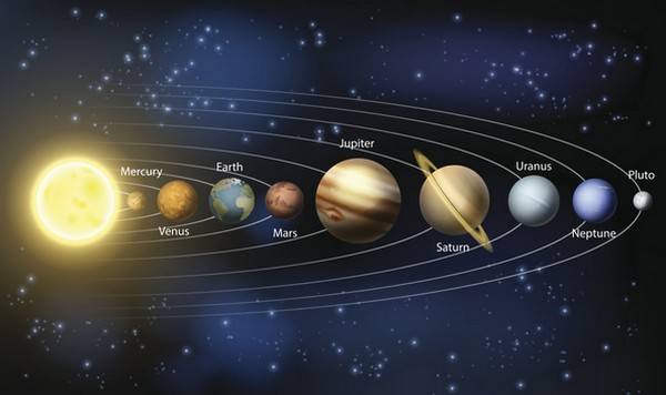
The Universe Scale » This Distance Is Equal To 9.46 X 10¹⁵ M Or 9500 Billion Km. Light Year Is The Unit Of Distance. 1 Parsec = 3.26 Light Years
The Globe Is A True And Small Image Of The Earth.
To Indicate A Place On The Globe, We Need Certain Points And Lines.
The Globe Is Tilted On A Wedge, Which Is Called The Axis Of The Globe. Is Called. The Two Points Through Which The Nail Passes Are Called The North Pole And The South Pole.
The Globe Is Divided Into Two Parts With The Help Of An Imaginary Line. This Imaginary Line Is Called The Equator/Equator.
The Northern Half Of The Earth Is Called The Northern Hemisphere And The Southern Hemisphere Is Called The Southern Hemisphere.
Latitude
All Parallel Circles, Which Run From The Equator To The Poles, Are Called Lines Of Latitude. Latitude Is Measured In Degrees. The Equator Is The 0° Latitude Line.
The Latitude Lines Located North Of The Equator Are Called “Northern Latitudes” And The Latitudes Located To The South Are Called “Southern Latitudes”.
Some Important Latitude Lines
- Equator : 0° Latitude Line
- North Pole: 90° North Latitude Line
- South Pole: 90° South Latitude Line
- Tropic Of Cancer 23 1/2° North Latitude Line
- Tropic Of Capricorn: 23 1/2° South Latitude Line
- Arctic Circle: 66 1/2° North Latitude Line
- Antarctic Circle : 66 1/2° South Latitude
Heat Zones Of The Earth
The Sun Is Directly Overhead At Least Once A Year At All Latitudes Between The Tropic Of Cancer And The Tropic Of Capricorn, Due To Which This Region Receives Maximum Heat And Is Therefore Called The Tropics.
The Midday Sun Is Not Over The Head At Any Latitude Beyond The Tropic Of Cancer And The Tropic Of Capricorn.
The Angle Of The Sun’s Rays Decreases As We Move Towards The Poles. Thus, The Region Bounded By The Tropic Of Cancer And The Arctic Circle In The Northern Hemisphere And In The Southern Hemisphere By The Tropic Of Capricorn And The Antarctic Circle Has Moderate Temperatures. Therefore, They Are Called Temperate Zones.
The Places Between The Arctic Circle And The North Pole In The Northern Hemisphere And Between The Antarctic Circle And The South Pole In The Southern Hemisphere Are Very Cold. This Is Because The Sun Does Not Rise Above The Horizon Here. Due To Which The Rays Always Fall Oblique Here. Hence, They Are Called As The Torrid Zone.
Longitude
In Order To Find The Actual Location Of Any Place, We Must Know How Far East Or West This Place Is From A Line Running From The North Pole To The South Pole. These Lines Are Called Meridians Of Longitude.
These Are Semicircular And As We Move Towards The Poles, The Distance Between Them Continuously Decreases And Becomes Zero At The Poles Where All The Longitudes Meet.
All Longitude Lines Apart From Latitude Lines Are Of Equal Length. The Line Of Longitude Passing Through Greenwich, Where The British Royal Observatory Is Located, Is Called The Prime Meridian. Its Value Is 0° Longitude And From This We Calculate 180° East Or 180° West.
The Prime Meridian Divides The Earth Into Two Equal Halves, The Eastern Hemisphere And The Western Hemisphere.
Local Time Can Be Calculated From The Shadow Cast By The Sun Which Is Shortest At Noon And Longest At Sunrise And Sunset. At Any Place, When The Sun Is At Its Maximum Height In The Sky, Then The Time Of The Clock Can Be Fixed At 12 O’clock I.E. At Noon. The Time Shown By This Clock Will Be The Local Time Of That Place.
When The Sun Is At The Highest Point In The Sky At The Prime Meridian Of Greenwich, It Will Be Noon For All Locations At This Longitude.
As The Earth Rotates From West To East, Places East Of Greenwich Will Be Ahead Of It And Places West Of It Will Lag Behind.
The Rate Of Difference Can Be Calculated As Follows. The Earth Rotates 360° In About 24 Hours I.E. It Rotates 15° Every Hour I.E. It Rotates 1° In Four Minutes.
An Important Function Of Longitude Is To Determine Local Time Relative To GMT.
Standard Time . The Time Of A Country Or A Region Is Standardized To Remove The Difficulties In Adjusting The Local Time. For This, The Longitude Line Passing Through Almost The Middle Of The Country Or Region Is Considered As The Standard Longitude.
East Longitude In India Is Considered As Longitude For Standard Time Because The Eastern Longitude Line Passes Almost Through The Middle Of India.
India’s Standard Longitude Line Is 82 1/2° While The Time Of East Longitude Is 5 1/2 Hours Ahead Of Greenwich Time.
Note: Some Countries Have A Large Range, So More Than One Standard Time Has Been Adopted. For Example, There Are Eleven Standard Time In Russia. There Are Nine Standard Time In The US. Earth Is Divided Into 24 Time Zones Of One Hour Each. Thus Each Region Has 15° Longitude.
International Date Line
The International Date Line Has Been Determined With The Help Of 180° (East And West) Longitude.
One Day Is Increased When Going West Of The International Date Line And One Day Is Decreased When Going East. That Is, There Is A Difference Of One Day Between The East And West Of The International Date Line.
In The Central Pacific, The International Date Line Turns From The Normal 180° Longitude Over The Bering Strait, Fiji, Tonga And Other Islands To Form Some Of The Islands That Are Separated By This Longitude. To Avoid Confusion Of Day And Date.

